Description
Parrot ANAFI USA GOV Edition | Designed for Government Agencies
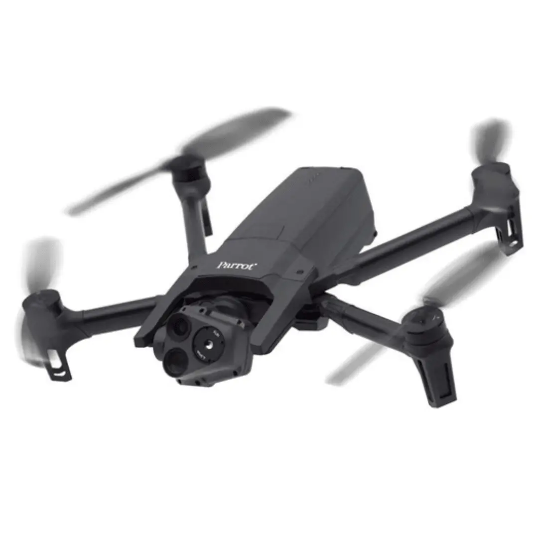
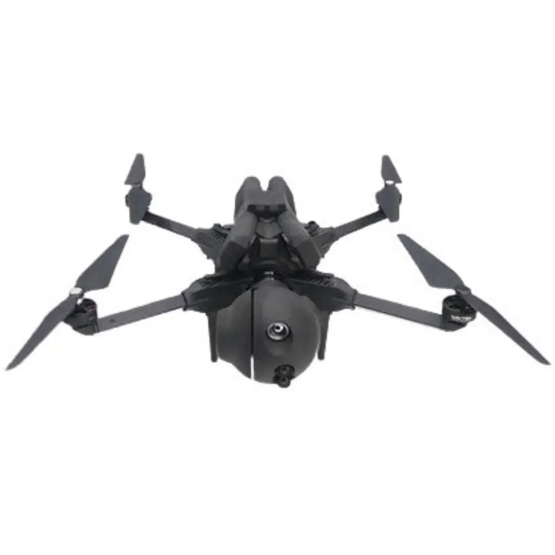
Designed specifically for government use, the Parrot ANAFI USA GOV RGB/Thermal Drone with Skycontroller USA is NDAA/TAA compliant and manufactured in the US, delivering a secure, rugged, and high-quality solution for government operators. Its compact, foldable design allows for hand launch and recovery, while the polyamide and carbon fiber construction is built to endure extreme temperatures, rain, wind, and other demanding conditions. The integrated dual-camera system captures 4K HDR visual video alongside precise thermal imagery, with up to 32x zoom for monitoring targets at distances of up to 1.24 miles. Operation is handled through the Skycontroller USA remote, featuring a built-in 8″ display, 720p live video streaming, Wi-Fi 4 (802.11n) connectivity, and up to 4.5 hours of battery life.
Stabilized X32 Zoom Thermal Imagery | 4K Visual Excellence
- Visual Camera: As part of the 3-axis gimbal with hybrid stabilization, the visual camera of the ANAFI USA GOV is capable of recording 4K HDR from wide-angle to telephoto, thanks to a 32x zoom system. This allows for observation of subjects and objects from up to 1.24 miles away. The zoom is continuous, with up to 5x lossless zoom in 4K resolution, up to 10x in 1080p, up to 15x in 720p, and up to 27x in 480p
- Thermal Camera: As part of the 3-axis gimbal with hybrid stabilization, the thermal camera of the ANAFI USA GOV is capable of detecting centimetric hot spots from up to 131.2′ away. Using FLIR Boson 320, this thermal imaging is essential when inspecting industrial sites. Choose from Fusion, Rainbow, White Hot, and Black Hot color and black & white palettes. The resolution is 320 x 256, but with IR/visible blending, thermal images are blended with a visual version to compensate, resulting in 720p images and video with increased details and contrast. Additionally, Thermal Analyzer Mode (as part of FreeFlight 6 USA) can be used to make a quick thermal analysis and give you full control over the on-screen rendering of any photo or video.
Compact and Durable | Easy to Operate
The 1.1 lb compact, foldable airframe is small enough for palm-based or vehicle-based takeoff and landing, with unpacking and deployment completed in under 55 seconds. The system supports flight speeds and wind resistance up to 33 mph and features a polyamide body reinforced with carbon fiber for enhanced resistance to rain, impacts, dust, and extreme temperatures. Additional capabilities include tool-free propeller replacement, IP53-rated dust and water resistance, and zero no-flight zone limitations.
Trusted and Secure | Security First for Professional Users
Data is designed to remain safe and secure when using the ANAFI USA GOV. Optional SD card data is encrypted using an AES-XTS 512-bit key, and communication between the drone and controller is protected with WPA2. The operating system is secured with standard embedded system access controls, software updates are digitally signed, and default settings are configured to transmit no data.
Skycontroller USA
The ANAFI USA Gov is ready for operation right out of the box with no additional phone or tablet required. The controller features a large, built-in 8″ display based on the Samsung Galaxy Tab A tablet. Drone connectivity is handled via Wi-Fi 4 (802.11n), delivering a live HD 720p video feed along with essential telemetry data. Built for rugged environments, the Skycontroller USA is IP53-rated for dust and water resistance and provides up to 4.5 hours of operation on a full charge from its 5000mAh battery.
Advanced FreeFlight 6 Mission & Navigation Capabilities
Powered by the robust FreeFlight 6 ecosystem, ANAFI delivers durable, reliable, and accurate performance with mission-specific features built in. FreeFlight 6 provides advanced piloting capabilities, including fly-by-coordinates for assisted framing or fully autonomous flights using defined points of interest, waypoints, and landing points based on GPS, GLONASS, and GALILEO satellite navigation systems. The platform enables visual tracking through a proprietary deep neural network and machine-learning AI, direct on-screen reading of scene coordinates, and the ability to drag and drop a return-to-home point on the map. Coordinates and GPS positions can be displayed, reused, and shared to quickly locate points of interest or detected subjects, and the system interfaces seamlessly with Pix4Dcapture and Pix4Dreact for fast, offline 2D mapping workflows.
The Parrot ANAFI USA Gov Edition | Delivering secure, durable, and autonomous flight in a compact, mission-ready platform.
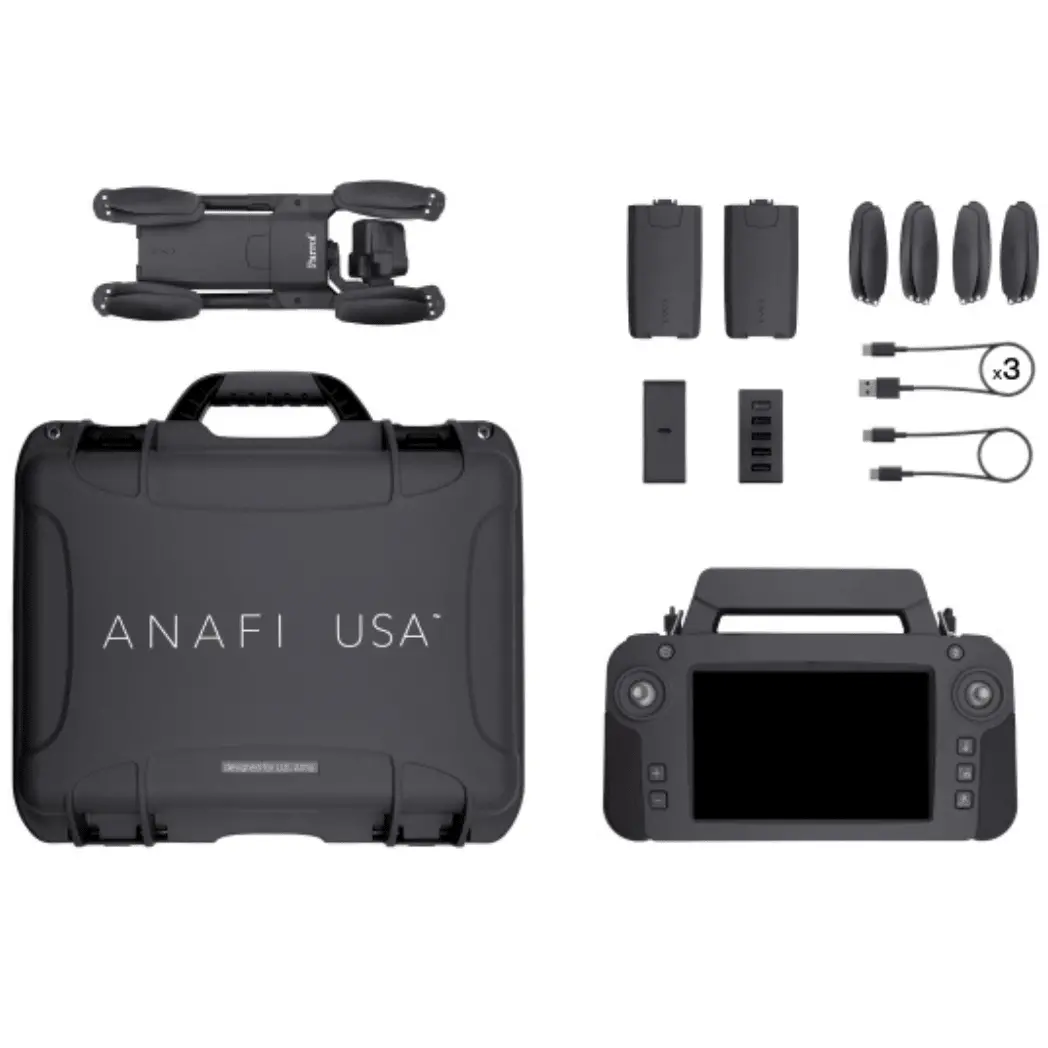
In the Box
1 – ANAFI USA Drone
3 – Smart Batteries (3×32 minutes)
1 – Skycontroller USA with its 8-in Display
1 – Multi-port Fast USB Charger
1 – Skycontroller USA Charger
1 – Additional Set of Propeller Blades
3 – USB-A/USB-C Cables
1 – USB-C/USB-C Cable
1 – Hard Case
Specifications
| Maximum Flight Time | 32 Minutes |
| Remote ID | Yes |
| Camera System | Wide 21 MP, 1/2.4″-Type CMOS Sensor with f/2.4 Lens (110° FoV) Telephoto 21 MP, 1/2.4″-Type CMOS Sensor with f/2.4 Lens (26° FoV) Thermal Vanadium Oxide (VOX), Long Wavelength Infrared (LWIR) Sensor with -40 to 302°F / -40 to 150°C Measurement Range with 4.3mm-Equivalent Lens (50° FoV) |
| Maximum Video Resolution | Wide Up to UHD 4K at 24 fps Telephoto Up to UHD 4K at 24 fps Thermal Up to 720p at 9 fps |
| Still Image Support | Wide Up to 21 MP (DNG / JPEG) Telephoto Up to 21 MP (DNG / JPEG) Thermal Up to .08 MP (JPEG) |
| Control Method | Included Transmitter with Smartphone/Mobile Device |
| Weight | 1.1 lb / 500 g (Takeoff) |
Performance
| Maximum Horizontal Speed | 32.9 mph / 52.9 km/h |
| Maximum Ascent Speed | 8.9 mph / 14.3 km/h |
| Maximum Descent Speed | 6.7 mph / 10.8 km/h |
| Maximum Wind Resistance | 32.9 mph / 52.9 km/h |
| Maximum Take-Off Altitude | 3.1 Miles / 5000 m |
| Maximum Flight Time | 32 Minutes |
| Maximum Tilt Angle | Not Specified by Manufacturer |
| Hovering Accuracy | Not Specified by Manufacturer |
| Maximum Angular Velocity | 300°/s |
Aircraft
| Rotor Configuration | Quadcopter |
| Remote ID | Yes |
| Operating Conditions | -32 to 122°F / -36 to 50°C |
Imaging
| Number of Cameras | 2 (Cannot Be Used Simultaneously) |
| Camera System | Wide 21 MP, 1/2.4″-Type CMOS Sensor with f/2.4 Lens (110° FoV) Telephoto 21 MP, 1/2.4″-Type CMOS Sensor with f/2.4 Lens (26° FoV) Thermal Vanadium Oxide (VOX), Long Wavelength Infrared (LWIR) Sensor with -40 to 302°F / -40 to 150°C Measurement Range with 4.3mm-Equivalent Lens (50° FoV) |
| Zoom | Wide 5x Digital Telephoto 32x Optical Thermal 32x Optical |
| ISO Sensitivity Range | Wide 100 to 3200 Telephoto 100 to 3200 |
| Night Vision | No |
| Shutter Speed | Wide Electronic Shutter: 1/10000 to 1 Second (Photo/Video) Telephoto 1/10000 to 1 Second (Photo/Video) |
| Maximum Video Resolution | Wide Up to UHD 4K at 24 fps Telephoto Up to UHD 4K at 24 fps Thermal Up to 720p at 9 fps |
| Still Image Support | Wide Up to 21 MP (DNG / JPEG) Telephoto Up to 21 MP (DNG / JPEG) Thermal Up to .08 MP (JPEG) |
| Photo Modes | Interval, Single Shot |
| Media/Memory Card Slot | In Aircraft Body microSD (Unspecified Type) |
| Internal Storage | No |
Gimbal
| Number of Axes | Three: Pitch (Tilt) / Roll / Yaw (Pan) |
| Rotation Range | Controllable Range Pitch (Tilt): 180° (-90 to 90°) |
Remote Controller / Transmitter
| Control Method | Included Transmitter with Smartphone/Mobile Device |
| Transmission System | Wi-Fi 4 (802.11n) 2.4 GHz / 5.1 GHz (5.18 to 5.24) / 5.8 GHz (5.745 to 5.805) |
| Maximum Operating Distance | Not Specified by Manufacturer |
| Transmitter I/O | 1x USB-C (Power) 1x USB-C (Expansion) 1x Micro-HDMI Output (Video) |
| Clean Video Output | Not Specified by Manufacturer |
| Battery Type | Built-In Lithium-Ion (3350 mAh) |
| Mobile Device Compatibility | Devices up to 8″ / 20.3 cm Wide |
| Mobile App Compatible | No |
| Dimensions | 9.4 x 5.8 x 2.2″ / 238 x 147 x 55 mm |
Flight Battery
| Battery Chemistry | Lithium-Ion Polymer (LiPo) |
| Battery Capacity | 3400 mAh |
| Battery Configuration | 3 S / 11.55 V |
| Maximum Charging Power | 30 W |
| Weight | 0.4 lb / 195 g |
General
| GNSS Support | GPS, GLONASS, Galileo |
| Overall Dimensions | 9.9 x 4.1 x 3.3″ / 252.0 x 104.0 x 84.0 mm (Folded) 11.1 x 14.7 x 3.2″ / 282.0 x 373.0 x 82.0 mm (Unfolded) |
| Weight | 1.1 lb / 500 g (Takeoff) |
Explore more from our collection.

Reviews
There are no reviews yet.